|
The
Solway Coast – Gretna to Dumfries.
Singular
advice to anyone exploring the Dumfries and Galloway
region for the first time is to do some homework on what
there is to see and enjoy. The certainty is that you will
be amazed at the variety of places and scenes, and time to
see it all will suddenly grow very short. And an extra
roll of film in your pocket will not be amiss. It is
perhaps these factors that cause many to return.
It is well
worth visiting the web site of the Dumfries and Galloway
Family History Society who are at
www.dgfhs.org.uk .
Also enjoy the photography of Sandy Pittendreigh
which covers a wide range of places and views of the
region to visit – available at
http://homepages.rootsweb.com/~dfsgal/. The use of
some of Sandy`s photographs and the following map in my
articles is gratefully acknowledged. Also visit Ian
McClumpha`s site for good guidance on researching your
ancestry in Dumfries and Galloway – at
www.imchad.freeola.com

The Solway
Firth on the west coast of Britain is the boundary between
England and Scotland. Cutting into the land mass for some
eighty miles it has long been a place of mystery and
intrigue and a landing place for all kinds of visitors
over the centuries. Across the Firth lies Cumbria, and the
Isle of Man is not far off in the Irish Sea, while
Ireland itself is just over 20 miles from the Mull of
Galloway. The ancient region of Galloway has an
association with all three that goes back into the Dark
Ages.
 The The
name Solway is thought to come from the Norse `Sol`
meaning mud and `vad` or `vath` meaning a ford. The
earliest mention is the Sulewade Patent Rolls of 1218.
Solway Sands came to mean the extreme east end of the area
and in 1300 Caerlaverock Castle was regarded as
looking out over the Irish Sea. In the seventeenth century
the Firth was extended gradually to include the
whole area and The Salmon Fisheries (Scotland) Act 1868
fixed the limit as a straight line drawn from the Mull of
Galloway to Hodbarrow Point, at Millom in Cumberland.
It is also
a region which is slightly off the beaten track for
tourists, yet those who have been there are certain to
return. It might be as well to explain that there are
three shires in the south west of Scotland – Wigtown,
Kirkcudbright and Dumfries. The ancient region of Galloway
was made up of Wigtownshire and Kirkcudbrightshire
(more properly known as the Stewartry of Kirkcudbright –
being the lands of the Douglases which were forfeit
and subsequently managed by the King`s Steward) and is
joined today in region termed Dumfries and Galloway.
Travelling
from England the route is to Carlisle, just beyond which
is Gretna Green and the main road (A75) to Stranraer.
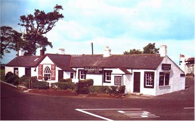
Literally within
yards of the turning is the `old smithy` to which young
lovers once eloped to get married. Today the smithy is
highly commercialised with a modern hotel adjacent and
still used for weddings, with local ministers officiating.
Marriages there, accompanied by a piper in full dress to
lead the bride and groom from the wedding room, is very
popular with young Japanese couples. From Gretna Green it
is possible to travel on the coast roads ( B721, B724,
B725) that run almost parallel with the main route to
Dumfries, and enables the traveller to take in the peace
and quiet as well as the scenery of the Solway coast.
On the way
lies the small village of Ruthwell which has an ancient
Anglo Saxon Runic cross from about the 8th century
installed in the local church.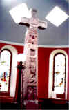
Saved from destruction by ministers of the kirk who buried
it in the 17th century to save it being broken up, and
recovered by later generations, the 18 foot cross has been
installed in its own well in an extension of the church.
Much credit for saving the cross is given to the
Rev. Henry Duncan (1774-1846) who is also responsible for
fathering the Savings Bank movement in 1810. Among his
other interests was geology and he was the first to
identify fossil footprints in Britain – at Corncockle
Quarry, Lochmaben. A museum about the savings bank and the
Rev Duncan is in the village and well worth a visit.
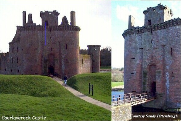
From
Ruthwell swing down onto the B725 which road will take you
to the wild fowl trust at Blackshaw and the ancient castle
at
 Caerlaverock. Caerlaverock.
The castle`s design and situation is unique with a
triangular layout surrounded by a water filled moat within
an earthen rampart. Built in the 13th century from red
sandstone the castle can take on a pinky glow in the right
light. It had a Scots garrison in 1300 and was later
besieged by Edward I of England. Variously stormed and
rebuilt in later years it was restored by the Maxwell
family in the 16th century. In 1640 it was a royalist
stronghold during the Bishops Wars and was besieged for 13
weeks before Robert Maxwell, 1st Lord Nithsdale, finally
surrendered to the Scottish army.
From
Ruthwell the road leads north along the side of the Nith
Estuary and into Dumfries at the head of Nithsdale. This
ancient town has much to see and

enjoy, not least are its connections with the Middle Ages
and a fording place for pilgrims making their way to
Whithorn. There was probably a church here since about
1180 and the tolbooth was first mentioned in 1481 with
shops on the ground floor and the council room above. Next
door a prison was built in 1579. The Greyfriars
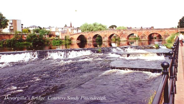
established a monastery here in 1262. A centre piece is
Lady Dervorgilla`s bridge the oldest spanned bridge in
Scotland. Tradition has it that a wooden bridge was first
built about 1260, although records are only from 1426 and
show that charges for passing over it were given to the
Greyfriars monastery.
Devorgilla
was the daughter of Allan, Lord of Galloway (sometimes
called King of Galloway) and the last Constable of
Scotland. She married John de Balliol founder of the
college at Oxford. When he died in 1264 the disconsolate
widow had his heart embalmed and took it everywhere
with her in a casket. The original bridge across the River
Nith in Dumfries was also in his memory. Devorgilla
founded the abbey south of Dumfries that was first called
the New Abbey, but on her death she and her casket were
buried under the high altar. It has since been called the
`Sweetheart Abbey.` Although now a ruin, it is still worth
a visit to see what must have been a stupendous building
in its day.
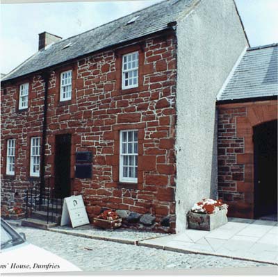
 Robert Robert
Burns was a resident of Dumfries in his later years and
there is an extensive visitors centre. Also worth a visit
is the house he occupied in the last three years of his
life and in which he died in 1796, aged thirty
seven. The house has been converted into a museum and
contains many mementoes and relics of the bard. These
include the gun he carried as an Exciseman, and original
letters as well as copies of his Kilmarnock and Edinburgh
editions of his works. His mausoleum in St Michael`s
Churchyard is worth visiting and for the Burns devotees
the graves of several of the bards associates are also
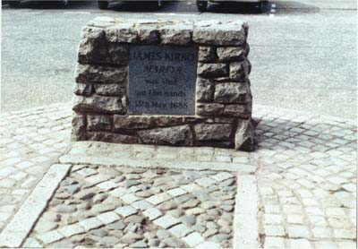
marked out. Within the churchyard there are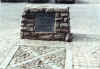
also several monuments to Covenanters who gave their lives
for their faith including John Kirko who has a
commemorative cairn marking the spot at which he was shot
on the Whitesands, beside the river.
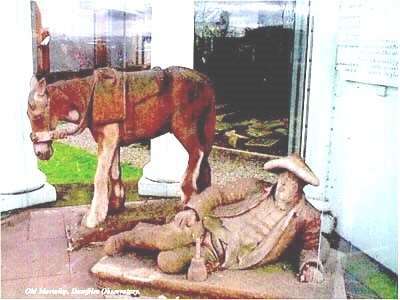
There is
much to see and experience in Dumfries and it is difficult
to decide what to refer to. Perhaps lastly, a novel
experience is to visit the Camera Obscura which is mounted
within an old mill. The building was adapted as an
observatory and the instrument installed in 1836 and gives
panoramic views of Dumfries. On a clear day it allows
views for many miles. Adjacent to the observatory is a
glass enclosed original statue of
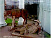 `Old `Old
Mortality` and his faithful steed. Robert Paterson is
buried at Caerlaverock but was born in Balmaclellan ca
1713 and spent his life engraving and maintaining
gravestones, especially those of the Covenanters. He
gained fame through the pen of Sir Walter Scott who met
him when he was renovating stones at Dunnottar. Other
statues of him are to be found at the Newton Stewart
museum.
Next Ruthwell and its Cross
|